

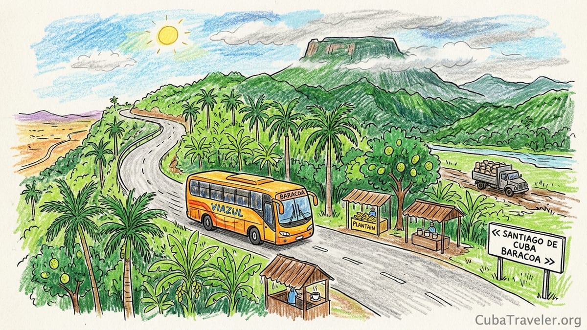
The road to Baracoa began for me in the exhaust haze of Santiago de Cuba’s bus station, with a wrinkled ticket in my hand and a warning from the clerk: “If there is fuel, the Viazul will leave. If not, it will be later.” In 2026, that is how travel works in eastern Cuba. Nothing is guaranteed except delays, improvisation and your own patience. What I did not yet know that morning was how sharply the island would change between the dry hills outside Santiago and the soaked green world around Baracoa, where cacao trees drip with humidity and the flat summit of El Yunque hangs over town like a stone cloud.
Arriving at the Edge of Cuba: Santiago to Baracoa on La Farola
Leaving Santiago de Cuba on the morning Viazul, the landscape felt almost sunburned. The bus rolled past low, scrubby hills and skinny cattle, the earth around them baked in tones of beige and rust. We rattled through villages where fuel queues stretched beyond intersections and drivers waited with plastic containers, hoping a tanker would appear. The driver warned us that the journey to Baracoa could take “four or five hours, or maybe more, if we have to slow down to save diesel.”
Once the road began to climb toward La Farola, the famous mountain highway built in the 1960s to connect Baracoa with the rest of Cuba, the sense of isolation intensified. There were long stretches without mobile signal and almost no other vehicles. Our bus groaned into first gear on steep curves, and several times we stopped so the driver could check the engine while the passengers stepped out into silence broken only by cicadas. La Farola is beautiful, but it is also a reminder that Baracoa is still the country’s end of the road.
With every kilometer the scenery changed. Dry slopes gave way to slopes striped with banana plants and breadfruit, then dense stands of royal palms. The air became heavier and cooler, touched by Atlantic moisture drifting over the mountains. Around the highest points of La Farola, mist clung to ridgelines and we passed small stalls selling plantain chips and coffee under dripping wooden roofs. By the time the bus began its descent, it felt like a different Cuba entirely.
We reached Baracoa in the late afternoon, the bay half-hidden behind low clouds and, far to the west, the unmistakable table silhouette of El Yunque rising to roughly 575 or 576 meters above sea level. The streets were quiet. Electricity had returned only a few hours earlier after an outage the previous night, and people were hurrying to charge phones and run refrigerators while they could. It was immediately clear that reaching Baracoa is both a logistical and emotional crossing into another Cuba.
Baracoa, Cuba’s First Spanish City in a Wet Green World
Baracoa likes to call itself the Ciudad Primada, the first city of Cuba, and that claim is rooted in history. The town was founded in 1511 by the Spanish under Diego Velázquez de Cuéllar and served briefly as the island’s first capital and bishopric. Its early role as an administrative center is documented, even if many of the surrounding stories about hidden crosses and miraculous escapes belong more to legend than to archives. Walking its compact center, you feel that layered past in weathered facades, the cathedral square and the low, thick-walled fortresses facing the sea.
The town’s early isolation helped shape its culture. For centuries there was no road over the mountains, only precarious tracks and coastal approaches by boat. Even today, with La Farola technically linking Baracoa to the rest of Cuba, the town still feels like a separate island. The heavy rains that soak this northeastern corner contrast sharply with the drier tobacco plains of Pinar del Río and the limestone valleys of Viñales in the west, and Baracoa’s agriculture reflects that difference.
Instead of orderly tobacco vegas under a high blue sky, Baracoa’s countryside is a tangled mosaic of cacao, coconut, fruit trees and secondary rainforest. The city opens toward the Atlantic, but behind it the rivers Toa and Duaba pour down from the Cuchillas del Toa, a biosphere reserve of deep green ridges. Everything here seems adapted to water: wooden houses on stilts in low areas, towering breadfruit shading muddy tracks, cacao trees with moss on their trunks and orchid-like epiphytes caught in forked branches.
In the evenings, the humidity presses in. Clouds snag on El Yunque, sometimes obscuring the mesa entirely. The streets smell of sea salt, diesel, wood smoke and occasionally fermenting cacao. That mix would define my days in Baracoa more than its early colonial plazas, because I had come above all to understand how chocolate, mountain and rainforest define this far eastern edge of Cuba.
Into Cacao Country: Visiting a Working Farm on the Toa River
The next morning I left town in a beat-up shared truck heading north along the Toa River valley, toward a small agroecological cacao farm that receives visitors. With fuel scarce in 2026, transport is improvised. The driver waited until every plank bench in the truck bed was full before we left, and he asked for payment in Cuban pesos, with a small top-up in euros if we could manage it. Cash matters here because card payments are unreliable when power fails and electronic connections drop.
The road soon deteriorated into patched asphalt and red mud. Cacao and coconut trees appeared, mixed with breadfruit, guava and plantain, all layered over each other so that every square meter seemed cultivated yet half-wild. At the farm, a family welcomed our small group under a wooden shelter roofed with palm leaves. This was not an industrial plantation but a mixed plot of a few hectares, cacao trees growing in the shade of taller species, their trunks cloaked in moss and lichen.
We walked between trees bearing football-shaped cacao pods in all colors of ripeness, from hard green to yellow, orange and deep red. Our host cut open a ripe pod and passed segments of the white, mucilaginous pulp around. I tasted the sweet-sour flesh and spat out the beans, which were already stained purple inside when split. It was the only part of the chocolate process that felt pleasant in the humidity. The rest, I learned, relies on heat, time and labor.
Behind the house, under a simple tin roof, the family showed us wooden fermentation boxes holding fresh wet beans covered with banana leaves. They explained that fermentation usually lasts about five to seven days, depending on the weather, and that regular turning is essential for flavor. After fermentation, beans are spread on raised drying beds that can be slid under the roof during sudden downpours. When we visited, some trays sat half-dry, the beans developing the familiar brown color and brittle shells. An older relative stirred them slowly with a wooden paddle, watching the sky for new clouds.
From Bean to Cup: Roasting, Grinding and Tasting Baracoa’s Chocolate
Inside the farmhouse kitchen, stained walls carried the smell of roasting cacao that no tourist brochure can quite capture. The family had a heavy, hand-turned metal roaster heated over charcoal. They poured in a batch of dried beans and invited us to listen as the shells cracked. It was brutally hot. Sweat ran down my back as we worked in rotations, turning the drum and trying not to lean too close to the charcoal.
Once roasted, the beans were cooled in wide metal bowls and then crushed with a rolling pin so that the brittle husks separated from the nibs. There was nothing automated about the process. We took turns hand-cranking an old grinder that spat out a thick, warm paste of cacao. The farmer’s daughter mixed this paste with coarse local sugar and a little water, kneading it on a wooden board into rustic tablets. These were not perfectly smooth bars, but dense, grainy pieces of cocoa that smelled intensely of earth and fruit.
Instead of tempering chocolate into glossy confections, the family focused on what people in Baracoa actually drink and eat. They prepared a traditional hot chocolate in battered aluminum mugs, stirring grated cacao tablets into boiling water with a pinch of salt and sugar. It was far less sweet than most commercial chocolate drinks, strong and slightly bitter. They also served chorote, a thick beverage where cacao is cooked slowly with a bit of maize flour, resulting in a porridge-like drink that locals consider both a breakfast and a tonic.
At the end of the visit, they offered their products on a simple table: rough cacao tablets, small bags of ground cocoa and wrapped cucuruchos made from grated coconut, honey, sugar and crushed nuts folded into cones of palm leaf. Prices in mid-2026 were listed in Cuban pesos, but the family was also open to euros, roughly equivalent to a few euros for a bundle of chocolate and cucuruchos, which felt modest considering the manual work involved. Paying in hard currency felt less like bargaining and more like a way of supporting fragile rural livelihoods in a year of fuel shortages and rising costs.
Cacao’s Humid Home versus Tobacco’s Dry Valleys
What struck me most about that farm was how perfectly Baracoa’s environment suited cacao. The trees loved the constant moisture. Afternoon downpours were frequent, and the air rarely felt dry, even in what locals consider the less rainy months. The canopy of taller fruit and shade trees protected cacao from direct sun and heavy raindrops, creating a filtered, green half-light in which moss, ferns and bromeliads thrived on every trunk.
This set of conditions stands in clear contrast to Cuba’s tobacco heartland around Viñales. In Pinar del Río province, high-quality tobacco is grown in well-drained red soils under a more pronounced dry season. Farmers there build curing houses for leaves and plan their sowing to avoid excessive rain that could damage the plants. Tobacco likes a balance of moisture and sun but not the persistent, saturating humidity that surrounds Baracoa almost year-round.
In Baracoa, leaf crops that dislike waterlogged soils struggle. Cacao, by contrast, benefits from the steady rainfall and the ability of shaded agroforestry systems to protect both soil and plant. On the farm, our guide emphasized how mixing native and fruit trees with cacao stabilizes slopes, keeps the microclimate cool and buffers against intense storms that can lash the northeast coast. Walking under that living umbrella, it was easy to see why this region has become synonymous with Cuban chocolate while Viñales remains the icon for cigars.
For travelers interested in agriculture, the comparison is compelling on a human level as well. In Viñales, tours often focus on cigar rolling and curing, with neat displays in wooden barns. In Baracoa, your shoes sink into mud between cacao trunks, and you may help turn fermenting beans or stir chorote over charcoal. The work feels more intimately tied to the rainforest and to the unpredictable rhythms of rain, rivers and storms.
Walking to El Yunque: Mud, Rivers and a 576-Meter Summit
My second full day in Baracoa belonged to El Yunque, the flat-topped mountain visible from almost every corner of town. I arranged a guided hike through a local agency the day before, paying in pesos at a rate that roughly matched information displayed at the official visitor post. The guide explained that the main route involves a combination of dirt road, trail and river crossings from near the Duaba River, with the full excursion covering in the region of 8 to 10 kilometers there and back. There is also a shorter option that focuses on the lower waterfalls and river pools, roughly 2.5 kilometers of walking, for travelers who do not want to tackle the summit.
We met at nine in the morning at the trailhead area, already warm and sticky. After registering and paying the park fee in local currency, we began along a farm track bordered by cacao, coconut and small plots of yucca. Within half an hour we reached our first river crossing. The Duaba ran brown and fast from recent rain, but just low enough that we could wade it with water at mid-thigh. The guide pointed out the slippery stones and advised us to keep shoes on rather than walking barefoot. My hiking boots filled with water, and I understood why locals prefer simple plastic sandals they can empty and dry quickly.
On the far bank the climb began in earnest. The path wound through small rural communities, where pigs rooted beside banana clumps and children waved from doorways. As we climbed higher, the trail narrowed and mud took over. Some sections were almost vertical slicks of clay, where we grabbed roots and tree trunks to pull ourselves upward. Heat built under the canopy, and sweat dripped off my elbows. Mosquitoes appeared whenever we stopped, especially in shaded, still-air spots near small streams, so we kept moving and reapplied repellent liberally.
After several hours of slow, steady climbing, the forest began to thin and low scrub replaced taller trees. The final approach to the mesa edge was on rock and hard soil rather than mud. We reached the summit area around early afternoon. The guide estimated the top at about 575 or 576 meters, in line with official figures, but altitude felt less important than the sudden, sweeping view. From the flat rocks at the edge we saw the line of the Toa River curling toward the sea, the patchwork of cacao groves, coconut stands and small villages, and far off, the faint outline of the Atlantic horizon.
Waterfall Option versus Summit: Choosing the Right El Yunque Experience
Reaching the summit was satisfying, but it was also demanding. The mud and heat added a layer of difficulty that should not be underestimated, especially for travelers not accustomed to tropical hiking. On the descent, my knees and thighs trembled, and I slipped more than once on wet clay. We arrived back at the river crossing tired and filthy but exhilarated. Only then did I fully appreciate the alternative option that many visitors choose.
The roughly 2.5 kilometer waterfall-focused route starts along the same initial track but turns toward natural pools and cascades lower on the Duaba and its tributaries. According to local guides and official materials, this shorter outing still involves walking on uneven terrain and some river wading, but it does not require the long, steep ascent to the top of El Yunque. Many travelers spend time swimming in clear pools beneath small falls, with the mountain looming above them like a dark green table.
If your priority is mountain scenery and a sense of accomplishment, the summit route is the better choice, provided you are reasonably fit and do not mind mud, sweat and several hours of sustained walking. If you are more interested in cooling off in rivers and being surrounded by rainforest without pushing to your limits, the waterfall route offers a very real experience of El Yunque’s environment in a shorter time frame. What both itineraries share is the intimate contact with Baracoa’s agroforestry landscapes: on either route you pass cacao trees, small farms and patches of secondary forest that link human and natural worlds.
Whichever option you choose, basic preparation makes a big difference. Closed shoes with good grip, a waterproof bag for documents, sufficient drinking water, snacks, and a lightweight long-sleeved shirt for both sun and insects all help. In the rainy months, guides may even recommend trekking poles or cut walking sticks to stabilize you in mud and at river crossings.
A Glimpse of Alejandro de Humboldt National Park and Practical Realities
On my third day, I joined a small group excursion toward Alejandro de Humboldt National Park, part of a larger protected area that spans several municipalities including Baracoa. Access is controlled and must be arranged with authorized guides who work with the park administration. We traveled by minibus as far as the road and conditions allowed, then continued on foot along a designated trail. The guide stressed early that while the park is famous for endemic plants, reptiles and birds, sightings of any particular species are never guaranteed. This is not a zoo but a rugged, often cloud-shrouded massif.
The trail led through low forest dripping with epiphytes and along sections of river where we stopped to refill bottles with filtered water. Interpretive signs in Spanish and sometimes English explained basic geology and ecology, but much of the learning came from the guide’s commentary. He described how the park’s complex geology and varied microclimates create niches for species that live nowhere else on Earth, and how climate change and human pressure around the edges threaten those habitats.
Reaching these protected areas from Baracoa requires time and flexibility. Fuel shortages in 2026 affect both private taxis and organized excursions. Agencies may cancel or combine departures if they cannot secure enough diesel or if too few participants sign up to make the trip viable. It is wise to plan extra days in Baracoa rather than scheduling back-to-back transfers, and to carry enough cash in a combination of Cuban pesos and foreign currency to pay for sudden changes in transport or accommodation.
Mosquitoes were a constant presence on both the El Yunque hike and the Humboldt outing. Repellent was essential, and guides recommended applying it after sunscreen, avoiding overly perfumed products and reapplying after river swims or heavy sweating. Long trousers and light, long-sleeved shirts provided a second layer of protection, especially at dawn and late afternoon when insects were most active. None of this eliminated bites entirely, but it kept them to a tolerable level and reduced distraction from the forest itself.
Staying, Eating and Paying in Baracoa’s Cacao Capital
Back in town each evening, Baracoa felt small but full of quiet movement. Most visitors stay in casas particulares, family-run guesthouses that rent out a few rooms. My lodging was in a simple two-story house a few blocks from the malecón, with a fan, intermittent air conditioning and water that ran most of the time. The owners offered breakfasts of fresh fruit, eggs and coffee, and dinners featuring fish, coconut milk stews and sometimes dishes with cacao. Given the national situation, I confirmed prices in advance and paid in cash at the end of my stay.
Electricity cuts were part of the rhythm of the day. One evening the power went out during dinner, and our hosts calmly brought out candles and a battery lamp. Refrigeration is fragile in this context, so I learned to eat what was available rather than insist on a menu. That flexibility extended to cafes and small eateries in the center, where options shifted according to recent deliveries and which ingredients had survived the latest outage.
Chocolate appeared everywhere, but not always in the form I expected. Some modest spots served cups of thick hot chocolate, often less sweet than versions elsewhere, for a price denominated in pesos that corresponded roughly to a small fraction of a euro. Cucurucho was easier to find: palm-leaf cones filled with coconut, sugar, honey and sometimes bits of fruit or ground cacao. Buying one from a woman under a doorway and eating it while watching the rain sweep in from the bay became a daily ritual.
Money management required attention. ATMs were not always functioning during my visit, and even when they were, foreign cards did not consistently work. I arrived with a mix of euros and small U.S. dollar notes, changed some into pesos at official and semi-official points, and kept the rest for larger expenses quoted in hard currency, such as certain excursions or private taxis. Baracoa’s economy in 2026 is a patchwork of official rates, informal arrangements and mutual accommodation between hosts and visitors trying to navigate a difficult moment.
The Takeaway
By the time I left Baracoa, bumping once again along La Farola toward Guantánamo and Santiago, I had spent several slow days negotiating mud, outages and uncertain transport. The question that lingered was whether the effort was justified. Of the region’s three big draws that I experienced firsthand cacao culture, El Yunque and the surrounding rainforest biodiversity one stood slightly above the others, though they were deeply intertwined.
Cacao culture was the most compelling thread. Hiking to the summit of El Yunque was unforgettable, and glimpses of Alejandro de Humboldt National Park hinted at vast ecological riches, but it was the smell of roasting cacao over charcoal, the sight of fermentation boxes under banana leaves, and the taste of chorote in a farmhouse kitchen that most fully rooted Baracoa in my memory. Cacao connected the heavy humidity, the shaded agroforestry plots, the history of Baracoa as an early colonial outpost and its current struggles with supply chains and fuel.
That said, the mountain and the rainforest framed and deepened that experience. Without the steep ridges and relentless rains that shape this corner of Cuba, cacao would not thrive as it does here, and El Yunque would not stand as such a powerful symbol above the town. The biodiversity of river valleys and protected areas, even when only partially glimpsed, gave context to every cacao pod and every cucurucho. Together, they created a sense of a living, working landscape rather than a curated attraction.
Reaching Baracoa in 2026 requires patience, flexibility and a tolerance for uncertainty. Fuel shortages stretch travel times, blackouts disrupt routines and cash can feel heavy in your pocket. Yet these inconveniences are also a lens through which to understand the resilience of Baracoans and the fragility of the systems that support both tourism and rural life. If you are willing to accept these conditions and travel slowly, Baracoa offers a rare combination of agriculture, mountain and rainforest that still feels, in many ways, like the edge of the known island.
FAQ
Q1. How difficult is the hike to the summit of El Yunque near Baracoa?
The main summit hike involves several hours of walking, steep muddy sections, at least one river crossing and tropical heat, so it feels moderately strenuous for most visitors.
Q2. Is there an easier alternative to reaching the top of El Yunque?
Yes. A shorter option of roughly 2.5 kilometers focuses on lower waterfalls and river pools, allowing you to experience the landscape without climbing all the way to the 576 meter summit.
Q3. Do I need a guide for El Yunque and Alejandro de Humboldt National Park?
For El Yunque, local guides are strongly recommended for navigation, river safety and access formalities. For Alejandro de Humboldt National Park, an authorized guide is generally required to enter official trails.
Q4. Can I count on seeing specific endemic animals in Alejandro de Humboldt National Park?
No. While the park protects many endemic species, sightings are never guaranteed, and any walk should be approached as a chance to experience habitat rather than a checklist.
Q5. How do current fuel shortages affect reaching Baracoa?
Fuel shortages in 2026 can cause bus delays, reduced departures and higher reliance on shared taxis, so journeys from Santiago de Cuba or elsewhere may take longer than published schedules.
Q6. What should I bring for cacao farm visits around Baracoa?
Bring cash in pesos and some hard currency, comfortable shoes for muddy paths, insect repellent, drinking water and a small bag if you plan to buy cacao products or cucurucho.
Q7. How is Baracoa’s cacao culture different from tobacco culture in Viñales?
Baracoa’s cacao grows in humid, shaded agroforestry plots tied to rainforest conditions, while Viñales tobacco depends on drier valleys, open fields and specialized curing barns.
Q8. Is it possible to pay by card in Baracoa’s casas particulares and cafes?
Card payments are unreliable because of power cuts and connectivity problems, so most travelers rely on cash for accommodation, meals and excursions.
Q9. What kind of mosquito protection is recommended for hikes and farm visits?
Use a reliable repellent, wear long sleeves and trousers when possible, and reapply after swimming or heavy sweating, especially at dawn and late afternoon.
Q10. Is Baracoa worth the effort if I have limited time in Cuba?
If you are especially interested in cacao, mountain hiking and humid rainforest, Baracoa can be a highlight, but the long, uncertain transfers mean it suits itineraries with extra days for delays.